
EAFS Geophysical Survey Services
In archaeology, geophysical surveying comprises a suite of ground-based physical sensing techniques used for archaeological imaging or mapping.
Geophysical survey is used to create maps of subsurface archaeological features. Geophysical instruments can detect buried features when their physical properties contrast measurably with their surroundings. In some cases, individual artefacts, especially metal, may be detected as well. Readings taken in a systematic pattern become a data set that can be rendered as image maps. Survey results can be used to guide excavation and to give archaeologists insight into the patterning of non-excavated parts of the site. Unlike other archaeological methods such as excavation, geophysical survey is neither invasive nor destructive. For this reason, it is often used to avoid disturbance of culturally sensitive sites.
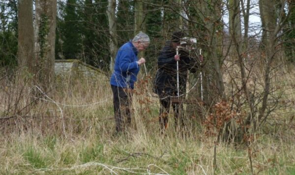
Geophysical surveying was introduced to the Society in 1989 and really took off in 2002. The main geophysical technique used is Ground Resistance which measures variations in electrical current due to differences in moisture content of buried features relative to their surroundings. Typically, substrates such as walls, building foundations, roads, and rubble spreads result in higher resistance values while ditches, foundation trenches and pits are lower due to the higher organic content of re-deposited or disturbed material. Using four probes, two fixed and two mobile which transmit a 70 Hz current and measure the returning voltage, readings are typically taken on a 20×20 metre grid and processed to produce a plan of buried anomalies.
There are plans to expand EAFS’s geophysical services due to the kind donation from Dr Peter Morris of Blairgowrie Geoscience of his Bartington Gradiometer and TR/CIA meter which will broaden our capabilities.
Geophysical surveys undertaken by EAFS have a wide geographic distribution across the Lothians, Borders and Fife region. They range from Lindores Abbey and Tullibardine in the North, to Culzean in the West and to St Abbs in the South. Notable sites include Cramond Roman Fort; Newhailes House walled garden; Morham; Castle Greg; White Castle, near Garvald; Sheriffside, Gifford and Standingstone to the East of Traprain Law where a prehistoric ring ditch and burials were later excavated by Durham University as part of the Traprain Law Environs Project. Many of the surveys are undertaken at the request of bodies such as the National Trust for Scotland, RCAHMS, County Councils, Local Authorities and other archaeology societies.
Our last survey prior to the Covid pandemic was at Old Lochend House, Dunbar in March 2020. In summer 2022 activities resumed with surveys at Bo’ness (the Antonine Wall and Kinglass Roman temporary camp) and Haddington where Haddington’s History Society and EAFS have teamed up to carry out an extraordinary survey of the grounds of Holy Trinity Church. Primary sources state that a Franciscan Chapel, reputedly a building so grand it warranted the title of the ‘Lamp of Lothian’, once stood in the grounds of the Episcopal Church; a geophysical survey may help identify the foundations of the Friary and thereby define the layout of the buildings.
A Short History of EAFS Geophysics
The story of EAFS Geophysics is mainly due to one source. Dave Jones, with assistance from Denis Smith managed the early history of the project. In 1989 Dave arranged the loan of a Geoscan RM4 Resistance meter from Edinburgh University School of Archaeology, and after some trials in the grounds of the Western General Hospital carried out the first survey in the walled garden of Newhailes House in Musselburgh between August and November of 1998. Further surveys were done at Colinton and Cramond, East Bonhard and Lauriston Castle. However, processing the results proved difficult – results using Excel and Geoplot were unsatisfactory.
All this changed in April 2002 when Dave took delivery of a TR/CIA Resistance Meter, frame, cable, and probes from TR Systems. A further boost came when Ian Hawkins and Alan Calder attended a session at Longmore House and were advised of the availability of freeware geophysics software called Snuffler developed by David Staveley of Sussex University. When used in conjunction with the Resistivity software supplied with the TR meter processing of results became much easier and quicker. The TR/CIA meter was updated in 2006 to allow auto-logging which eliminated a lot of button presses. Around this time Don Matthews became involved with EAFS geophysics and his planning, recording, sat-nav and GIS skills were of great value.
We are grateful to our sponsors, notably David Connolly, Dr John Wells, Local Authorities, Archaeology Scotland and many other local individuals and societies. We are also indebted to Dr Bruce Hobbs of the Edinburgh University Department of Geology and Geophysics and Dr Peter Morris for their assistance with Magnetic and Earth Resistance Tomography (ERT) surveys.
Finally, thanks are due to all our Society volunteers who brave all weather conditions to assist with our surveys.
A list of all surveys carried out is appended. Copies of all Geophysics reports have been scanned and are available on request.